Kategorier
Aktiviteter Hydrologidagarna Okategoriserade

Hydrologidagarna 6/10-2021

It’s soon time for our annual Hydrologidagarna (HD) with this year’s topic  “The value of water” on 6 October 2021. 

This year’s HD venue will be wonderspace, a virtual conference space with different ”virtual rooms” (waiting room, plenary speakers, different posters, lunch room, coffee room).
You can join the HD space through this link https://www.wonder.me/r?id=96b57cdb-10a1-406c-ac07-53ca9fe06215 and ”walk” with your virtual avatar from room to room and talk/ interact with the participants almost like on a real conference.

The plenary presentations are 20-30 min, followed by question. These presentations will be hold in the ”plenary speakers room”. During the coffee break or lunch we convene in the ”coffee or lunch room” to have more in depth discussions with all the audience or just have a coffee/leg stretcher.

After each coffee break there is a poster session similar to the EGU pico style:  The HD pico session starts with a 2-minute madness, where presenters give a short teaser of the work. After the 2-minute madness the audience can visit the different poster rooms. 

We are looking forward to an exciting day and learn more on the value of water from different viewpoints!

Programme

Time slot

Presenter

Organisation

Welcome

9:00

Benjamin Fischer & Lenka Kuglerova

SHR

Presenter 1

9:15

Luigia Brandimarte

Floods and society: dynamic mutual shaping

KTH

Presenter 2

9:45

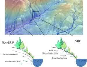
Lina Polvi Sjöberg

“Restoring riverine ecosystem services by understanding catchment-scale & catchment-specific processes”

Umeå Univeristy

Coffee break inc. question- discussion and leg stretcher

10:15

☕                    🙋‍♂️💭🤷‍♂️👨‍👨‍👦‍👦

Poster session 1

10:30

Lenka Kuglerova, Karin Eklof, Francesca Polato


Presenter 3

11:15

Berit Arheimer

Value of water – why is hydrological observations and services important for society?

SMHI

Presenter 4

11:45

Benjamin Fischer

How did European water education get impacted due to Covid19 measures?

Uppsala University

Lunch break inc. question- discussion and leg stretcher

12:15

🥪                            🙋‍♂️💭🤷‍♂️👨‍👨‍👦‍👦

Presenter 5

12:45

Stefano Manzoni

The value of water in carbon currency

Stockholm University

Presenter 6

13:15

Frauke Ecke

”Bävern: Frälsare eller bov i vattenlandskapet?” ”Beaver: Saviour or villian in the waterscape?”

SLU

Coffee break inc. question- discussion and leg stretcher

13:45

☕                    🙋‍♂️💭🤷‍♂️👨‍👨‍👦‍👦

Poster session 2

13:55

Anna Scaini, Nadine Gärtner, Susann Baez Ullberg, Michelle Nygren, Elisa Savelli 

Wrap up and goodbye

14:35

Benjamin Fischer

SHR

End of the HD 2021


SHR member meeting

15:00

SHR members only

SHR

Kategorier
Aktiviteter Monthly flash

Monthly flash: What is DRIPing into headwater streams?

Written by: Stefan Ploum & Lenka Kuglerová

A new study from the Swedish University of Agricultural Sciences (SLU) in Umeå shows that the tight link between headwater streams and surrounding hillslopes is especially important in so call DRIPs (Discrete Riparian Inflow Points, Fig. 1). The leading author of the study, Stefan Ploum (Fig. 2), explains that they found almost double the dissolved organic carbon (DOC) concentrations in groundwater in DRIPs compared to the rest of the riparian zone. This riparian DOC is exported to small streams by groundwater flow, which is also elevated in DRIPs. Thus DRIPs have an enormous control over the aquatic carbon balance on a landscape level. 

Figure 1. DRIP and non-DRIP riparian area is visualized using groundwater accumulation model derived from high-resolution digital elevation model (upper panel). More groundwater is accumulated in a DRIP (indicated by darker blue flow paths in the riparian area), while very little groundwater is flowing through non-DRIP area. Groundwater flow paths and groundwater table in the riparian area is conceptually visualized in the lower panels. Modified from Laudon et al. (2016). The role of biogeochemical hotspots, landscape heterogeneity, and hydrological connectivity for minimizing forestry effects on water quality. Ambio 45.

In earlier studies, DRIPs were found to have more diverse communities of riparian vegetation, wet and organic rich soils and higher nutrient content, and higher activity of aquatic organisms directly downstream of a DRIP. In his PhD thesis, Stefan Ploum explores the links between headwater streams and their surroundings. A large part of the thesis is devoted to the DRIPs and how we can use them to explain spatial heterogeneity in small streams’ water quality and quantity. That is why in Stefan’s work, a network of 63 riparian groundwater wells has been established in the Krycklan catchment in northern Sweden. These wells are systematically placed on DRIPs and neighboring non-DRIP areas along three different headwater streams. This paired design allow to compare DRIP and non-DRIP groundwater chemistry as well as the chemistry and hydrology of the adjacent streams.

Figure 2. Stefan Ploum is a PhD student at SLU, Umeå, studying the link between headwater streams and hillslopes areas, including winter dynamics of DRIPs.

From Stefan’s and others work, it starting to be increasingly evident that although DRIPs cover only small area of the riparian zone (only ca 12% of the riparian zone in the Krycklan catchment is characterized as a DRIP), they play a disproportionally large role in stream water quality and quantity. This is because ca 57% of the water flowing into headwater streams drains through DRIPs. Therefore the team has been suggesting that DRIPs should be considered in forest management plans, for example to be incorporated into riparian buffer design when upland forest is harvested. So called hydrologically adapted buffers (Fig. 3), where the buffer zones are wider on DRIPs and narrower on dryer riparian zones, is proposed as an alternative solution to currently more commonly implemented fixed-width buffers (uniform width of the buffer). It goes without saying, that protecting these parts of the riparian zone is crucial for local and downstream water quality, and stream ecosystem health. Fortunately, delineating DRIPs (Fig. 1) became easy with the availability of high resolution digital elevation models, and as such forest planners can account for those important riparian areas and help protecting the entire stream network.

Figure 3. A conceptual visualization of hydrologically adapted riparian buffer. Wider unharvested forest is left on DRIPs (visualized with blue shading) while buffers are narrower (or cut all the way to the water’s edge) in dryer, non-DRIP riparian zones. Modified from Kuglerová et al. (2017). Management perspectives on Aqua incognita: Connectivity and cumulative effects of small natural and artificial streams in boreal forests. HP 31.

More reading

Kuglerová, L., Ågren, A., Jansson, R., Laudon, H., 2014. Towards optimizing riparian buffer zones: Ecological and biogeochemical implications for forest management. For. Ecol. Manage. 334, 74–84. https://doi.org/http://dx.doi.org/10.1016/j.foreco.2014.08.033

Lupon, A., Denfeld, B.A., Laudon, H., Leach, J., Karlsson, J., Sponseller, R.A., 2019. Groundwater inflows control patterns and sources of greenhouse gas emissions from streams. Limnol. Oceanogr. 1–13. https://doi.org/10.1002/lno.11134

Ploum, S.W., Leach, J.A., Kuglerová, L., Laudon, H., 2018. Thermal detection of discrete riparian inflow points (DRIPs) during contrasting hydrological events. Hydrol. Process. 32, 3049–3050. https://doi.org/10.1002/hyp.13184